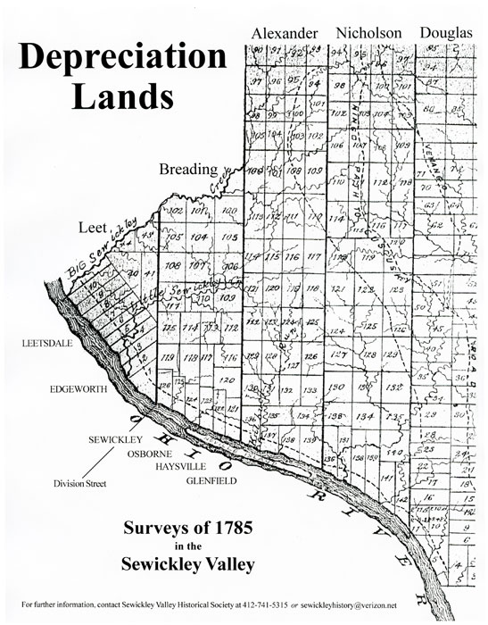
Depreciation Lands
You may have noticed that the Sewickley Valley Historical Society has recently installed blue and yellow signs in a number of Sewickley Valley boroughs to show the location of a north south line that runs through our lives. This was the first mark placed upon these lands by the Europeans, two hundred and twenty-five years ago in 1785. Here is the story.
Despite its location on a flat plain right on the Ohio River, the Sewickley area was not settled until after the Revolution. There were several reasons for this. Lands south of the Ohio River and to the east of Pittsburgh were more accessible and fertile and settled first. Also, both Pennsylvania and Virginia disputed the ownership of these western lands. Only in 1779 did negotiations lead to Virginia's relinquishing her claim. Most importantly, the Indians retained ownership of the land west of the Allegheny River and north of the Ohio River, and settlement by Europeans was forbidden.
The Six Nations (the Mohawks, Oneidas, Onondagas, Senecas, Cayugas and Tuscaroras) exercised control over the area, but it was mostly uninhabited and used for hunting by various tribes, some of them refugees forced westward by inexorable European pressure. There was an Indian village north of today's Ambridge called Logstown that had some fifty cabins, inhabited by Mohawks, Senecas, Oneidas, Delawares, Shawnees and Wyandots. Both English and French traders came there to do business. The French who sought to develop the Ohio River corridor as a link between their settlements in the Great Lakes and the Mississippi were forced out by the English and compelled to cede Canada in the French and Indian War (1756-1763); the English were themselves defeated by the Americans in the American Revolution (1776-1783). But, all the while, the Indian lands to the north of the Ohio River remained inviolate.
During the Revolutionary War, the soldiers of the Continental Army were paid by the Continental Congress with paper money known as Continental Currency. In the beginning this money was backed by gold, but as the war continued more and more paper money was printed with no gold to back it, and this caused the money to depreciate in value. By the end of the war, Continental Currency was virtually worthless, which gave rise to the expression "Not worth a Continental." The Commonwealth of Pennsylvania had to do something to help her poorly paid soldiers, and Certificates of Depreciation were issued that could be used for the purchase of land. An Act of the Pennsylvania Legislature passed March 12, 1783, provided for the purchase of the lands still owned by the Indians in western Pennsylvania and their sale or donation to veterans.
Treaties signed at Fort Stanwix, New York, on October 23, 1784, with the Six Nations and at Fort Mclntosh in Beaver, Pennsylvania, in January 1785, with the Wyandots and Delawares, extinguished the Indians' claims to the lands north and west of the Allegheny and Ohio Rivers. The amounts paid to the Indians were $5000 and $3000 respectively. There was the fear, later proved justified, that not all Indians would welcome an influx of settlers. Nevertheless, the huge tract of newly purchased land was divided into two great sections by a due east-and-west line running from Mahoning Creek, near Kitanning on the Allegheny River, to the western border of the state, and surveying commenced. The land north of this line was known as "Donation Lands" and was given to officers and soldiers according to their rank and service. The land south of the line was appropriated to the redemption of depreciation certificates, and these allotments were called "Depreciation Lands."
The Depreciation Lands were divided into five districts from west to east, and surveyors were appointed for each district to lay out the land in lots of 200 to 350 acres. The Sewickley Valley, bordered by Big Sewickley Creek to the west and Kilbuck Run to the east (today's Glenfield), fell within part of District2, surveyed by Major Daniel Leet, and a portion of District 3, surveyed by Nathaniel Breading (sometimes spelled Braden). The north-south dividing line between Leet's and Breading's Districts, stretching some thirty miles north, became Division Street, where that line runs diagonally through the town of Sewickley. The reason Division Street is on a diagonal in relation to the other streets in the town is that the town was laid out parallel to the river, which flows to the northeast in this area. The presence of this diagonal makes many of the blocks near it in the town irregular in shape, creating a street plan that looks more like a jigsaw puzzle than a grid.
When these surveys were completed in the summer of 1785, the sale of the land commenced at the Old Coffee House in Philadelphia. Sales did not go well, because most of the soldiers came from the eastern part of the state and did not want to move out to what was still wilderness. Also, the area was infested with marauding Indians who would not be subdued until General Anthony Wayne defeated them at Maumee, Ohio, August 20, 1794, at the battle of Fallen Timbers, and the treaty signed at Greenville ended all Indian resistance in the old northwest.
So most of the land did not, in fact, go to deserving veterans. Many soldiers, hoping to make a quick profit, sold their depreciation certificates to speculators. There are many examples of manipulation. In 1785, Mark Willcox, a wealthy mill owner and judge from Delaware County, paid £2,975 in depreciation certificates for 28 tracts of land totaling 6,302 acres in Leet's District. These were only a few of his many land purchases in the area. Then there was Thomas McKean, who had signed the Declaration of Independence, served in the Continental Congress, was Chief Justice of the Pennsylvania Supreme Court and later Governor of the state. He ended up owning 17 tracts in Leet's district, 10 tracts in Breading's district, four in Alexander's district and one in Cunningham's district. Some of these lands were up in the hills far from the river, but others were prime real estate. The surveyors themselves were not supposed to use their inside information for advantage, but they did. Major Daniel Leet obtained extensive and valuable land in Sewickley Bottom in the district he had surveyed, ultimately gaining possession of lots 3, 4, 5, 6, 7, 8 and 9. The lots held by him were known as Newbury, Norwich, Newington, Lincoln, Locust Bottom, Sugar Bottom and Leetsburg. This included all of the western part of what is today Edgeworth and Leetsdale, and some of this land remains in the possession of his family to this day.
Our town and our valley are arranged as they are today because of those surveys made more than 200 years ago. The surveyors' lines are there, invisible beneath our feet. Some of the original stones marking the sections can still be found. The borders of our Boroughs and Townships are all Depreciation lines. The surveyors of 1785 would be amazed that their marks still order and define our lives.